
|
|
|
|
|
|
|
|
||
| Watercourse | |
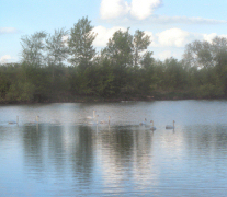
 Above is a photo of a naturally meandering river in Northeast Poland. The adjacent flood plain is used for grazing and has a high biodiversity. The water flows slowly and the natural processes sedimentation and denitrifikation is working. When the water flows this slowly erosion is also low, except short periods initially at flood events. An underestimated factor is our open ditches. There, denitrifikation and sedimentation occurs, but they are also susceptible to severe erosion and large transport of particulate phosphorus and nitrogen. Thus ditches may be high risk elements but also with inherent possibilities, depending on the design of the ditches. 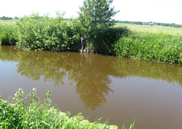 |
Protection of watercourses During the last 200 years we in the humid Nordic countries have worked hard to drain the landscape in order to secure the food production. A common feature of the drainage measures is a lowering of the water table to ensure drainage of surrounding lands. But how does it look if the landscape is left alone? In low lying areas soil particles in streams sediment (settle on the bottom). The river channel will get shallower and the water velocity decreases, letting even smaller soil particles to sediment. The channel will be increasingly shallower until the water reach the level of the surrounding flood plain. Shoaling is thus a natural process which gives us shallow and changeable rivers with large areas of the surrounding flood plains waterlogged. When the water naturally have a long retention time in the landscape, the bacteria in the sediment and on other surfaces will have ample time to transform Nitrate to harmless Nitrogen gas (80 % of the air consists of Nitrogen gas), by the process of denitrifikation. Along open ditches and watercourses both nitrogen and phosphorus are transported via soil particles, through erosion or by trampling of cattle on the river banks. More common is erosion of adjacent lands during heavy rainfall, when no barrier between field and river can hold back the soil particles. Phosphorus cannot be transformed into harmless forms by bacteria as with nitrogen. However a large fraction of phosphorus is in particulate form and when water velocity is low the particles, with the phosphorus, will sediment and thus the transport chain is broken. This is the second water purification process working naturally in the landscape. To revert to a natural, undisturbed landscape is not realistic, but instead we can design modern efficient wetlands. When we thus increase the retention time of the water in the landscape the natural processes can reduce the transport of nutrients to the recipients. Another important way to address the nutrient transport from arable land to rivers, lakes and the sea is to decrease the leakage at the source, from agriculture, industries and towns/villages. |
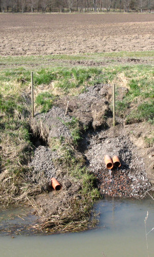 In the stream Nyrebäcken outside the city of Halmstad (photo to the right) the water is turbid large parts of the year and the transport of soil particles and nutrients are high. Continuously along the stream drainage pipes enters the stream. At high flows the soils are eroded away around the pipes and large amounts of nutrients are transported downstream. At high flow the pipe can also lift and come off due to trapped air inside the pipes, as can be seen in the photo. The restoration, as it is done does not change anything and in a few years the damage will be large again. Lot of soil is thus lost also around unstable pipes entering watercourses. They should be connected to larger drainage pipes going parallel to the watercourse before the water enter the streams preferably through a long and heavy concrete pipe. One major end pipe is always better than an number of small ones. |
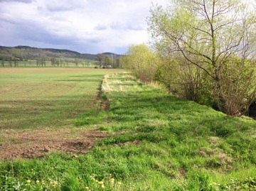
Buffer Strips Along open ditches and watercourses both nitrogen and phosphorus are transported via soil particles, through erosion or by trampling of cattle on the river banks. More common is erosion of adjacent lands during heavy rainfall, when no barrier between field and river can hold back the soil particles. Some protection against erosion can be achieved by leaving a grass covered zone the watercourse, thus creating a production free zone decreasing the risk of surface run-off from arable fields. The efficiency of the Buffer Strip is dependent on how the surface run-off passes over the zone. If an even overflow is possible the efficiency can be high. According to research in Norway a buffer strip should be at least 10 m wide, when the slope from the field to the watercourse is significant. The buffer strip can be designed to increase the biodiversity by e.g. stone cairns, piles of dead wood and other installations in areas not impeding the grass harvest. This will benefit a number of species of insects, amphibians and small mammals which also need hiding, resting and nesting places. The Buffer Strips should be sown with seed mix without clover and can be harvested and used for fodder in the middle July. The grass covered buffer strip can also be used as a stable field headland for the farmers field work. The economic loss when establishing buffer strips does therefore not have to be as large as one might suspect. At watering sites for cattle large amount of soil can be eroded by trampling. By fencing it is possible to limit the number of watering sites and also direct the animals to sites with gentle slopes. 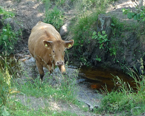 Finally: why should open ditches always be dug symmetrically? It would be very god to dig one side of the slope with a gentle inclinations thus giving valuable space for small mammals and amphibians. |
 This is what happens in practice and thus contrary to all theories and trials regarding the efficiency of buffer strips regarding surface run-off and erosion. It is almost impossible to design buffer strips with even and flat horizontal surface needed for an overflow that will not lead to erosion. It is not possible to construct a fully functioning buffer strip without changing the topography. The shortcomings of traditional buffer strips and other problems with drainage pipes entering watercourses have led us onto the new solution 2012, that we call “Integrated Buffer Zones”. This new innovation (photo right hand) takes care of all surface run-off and at the same time catch and infiltrate the drainage water in a lowered and levelled infiltration bank. |
Normal Buffer Strips are turned into
“Integrated Buffer Zones” When walking along a watercourse with buffer strips it is fairly obvious that the buffer zone always is at a higher elevation compared to the adjacent field. This is caused by the fact that the farmer wants a clean edge towards the field and therefore with the outmost furrow turns the soil inwards towards the field. This is practical for the field work and also protects against invading weeds from the buffer zone. The disadvantage from an environmental point of view is that all surface run-off is collected in this small groove/channel between the field and the buffer zone and then flows to the lowest point in the field where it sooner or later will start to overflow into the buffer zone. When the water flows over a surface in a particular spot and not over the whole stretch of buffer zone, it will erode more, since almost all the surface run-off from the field passes over a very small area, and after a while a small ditch through the buffer zone is created by erosion. It is not unusual for the farmer to help this process along with a shovel in order to remove standing water from the field. 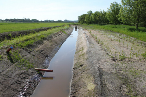 |
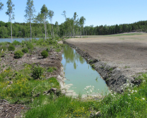 |
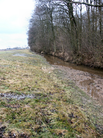
Open ditches The design of the ditches can cause an environmental disaster for the downstream recipient. Large amounts of nutrients will be transported, thus contributing to eutrophication. There are obviously lacking information, understanding and consideration towards the life in the sea. Open ditches are much better than covered drainage pipes from a nature conservations point of view. Some retention occurs in the ditch and some biodiversity as well. Unfortunately there are sub-optimally design ditches almost everywhere, as in the photo down here. Buffer zones on the right hand are missing and the ditch is designed with very steep slopes. The pressure from machines during field work close to the ditch will lead to the soil being pushed into the ditch. The biological value of the ditch is also very limited. 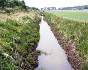 In a nature conservation project in the county of Skåne one side of the ditch have been designed with a very gentle slope. The result is not only positive for the environment and nature, but the area looks much more pleasing to the human eye. The forest on one side shadows the ditch leading to decreased overgrowth of macrophytes. This solution gives good conditions to stay open and beautiful a long time and decreases the need for the farmer’s management. |
 |
|
|
|
| © Peter Feuerbach |